Avalanches scare the living sh!t out of me. The thought of being crushed under a mass of moving snow, having snow force it’s way into my lungs instead of oxygen and slowly suffocating entombed in something akin to cold concrete (if the trauma hasn’t killed me first) is absolutely horrifying. I do not suffer from any disillusions that my sking skill (more like lack thereof) would magically allow me to outrun an avalanche. This is something that pro riders seem to do with apparent ease in many ski movies and partially makes me wonder if this attitude gives todays skiers a sense of complacency about avalanches.
 |
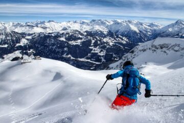
| Powder fun. |
Despite this fear I love to ski off-piste. The feeling of floating through fields of soft powder snow must be something similar to flying… It’s like riding an endless wave and when everything comes together it feels almost effortless. It’s probably one of the closest feelings to total elation we can get. But, it’s not only this feeling of elation, it’s also the places it takes me, the people I meet and the experiences we share that make the whole thing something very special.
 |
| Avalanche in Davos, Photo from SLF weekly report. here. |
Last week here in Switzerland 12 people were killed in Avalanches in 10 days. The basic details of all these accidents are available on the website of the Swiss Institute for Avalanche Research (SLF). For a number of years I have gone through many of these accidents as they occurred and asked myself what are the chances that I would have put myself in that situation had I been there. In many cases I can hand on heart say I would make the right decision… However, there are sometimes the odd case where it is not so easy.
Here in Switzerland the SLF issue an avalanche bulletin every day at 5pm. This bulletin is updated at 8am the following morning. We have information real time from snow monitoring stations, we have a weekly report on conditions in the week just past and we have snowpack stability information from around the country. All this information combined with some basic training and following simple rules would cut out all but the most random of avalanche accidents in the last number of years. Almost all of the 12 deaths which occurred last week could and should have been avoided.
 |
| Avalanche Danger Map from Jan 5th |
The main decision making tools for assessing if a slope is safe to ski or not here in Switzerland are the 3×3 method from Werner Munter (A three level matrix which helps decide go or don’t go based on information available to hand), the Reduction Method (A mathematical formula where the acceptable risk is calculated by dividing the risk level into the sum of any safety measures which might be taken. The outcome should be less than 1 for a tour to go ahead) or Graphical Reduction method (see diagram). By using these methods a recent study in Norway (where the same level of information is not available as in Switzerland) has shown that over 90% of avalanche fatalities could have been prevented… People are willing to spend large sums of money on Airbags to ensure their safety, but the most cost effective safety device is making a sound decision.
 |
| Graphical Reduction Method |
For education purposes I am going to look at each of the 12 fatalities which occurred last week because if one person can learn from these unfortunate accidents and not make the same decisions again then at least these deaths may serve some purpose in the future. This may be little comfort to the families of those already gone, but it might help to ensure (or reduce) the possibility of the same thing happening to others in the future. Please be aware that this analyis is very simplified and does not take into account the specific conditions found by the people on the ground. But it does show that a decision to not do the tour could have been made before the victims even arrived at the slope or at the very least should have provided red flags as to whether the route should have been altered or not.
NB: I have intentionally used the descriptive word rather than the avalanche level (number) to describe the danger level. The reason for this is due to the perception by some that an avalanche risk of level 3 of 5 is seen as middle of the road, whereas using the word “considerable” is actually more indicative of the real risk at level 3.
Accident 1:
Location: Realp 680880/159030
Avalanche Risk: High
Slope Steepness: ca. 40deg
A lone ski tourer was on his way towards the Rotunda Hut in poor visibility. Hit by avalanche (possibly from above) The route follows a river valley with steep slopes ca40deg on both sides of the valley. Routes to SAC huts are not made safe from Alpine dangers. At high avalanche risk spontaneous and remote triggered avalanches are to be expected. Avalanches can release very easily on any slope over 30deg. Roads and railways were closed due to the avalanche risk and some villages had even been cut off. At avalanche risk 4 any slope over 30deg should quite simply be avoided and even slopes close to 30deg should be attempted only with additional safety measures.
Go or don’t go decision:
3×3: Fails on the first level already at the tour planning stage this tour should have been deemed as no go. (High Avalanche Risk, Poor Weather, Specific Warnings of Avalanche Activity, Slopes above 30deg) Dont’ Go
Reduction Method: Danger Level = 16 (i.e. greater than 1) Don’t Go
Graphical Reduction Method: Slopes greater than 30deg above the planned route and some 30deg slopes need to be crossed on route. Don’t Go
Accident 2:
Location: Piz Nair 780320/153200
Avalanche Risk: Considerable
Slope Steepness: ca. 40deg
The avalanche risk had come down from high to considerable over night. There had been road closures and train cancellations due to the avalanche risk in the valley. All slope aspects over 2000m were declared dangerous. Signs of wind loading in the area and at almost the same time as this avalanche another smaller avalanche crossed a piste in the same area. This was the first snowfall of the season that would have made Piz Nair potentially rideable so the slope could not have been considered heavily skied. (heavily skied slopes offer some level of risk reduction) The area is at high altitude and it had been very cold between the last snowfall earlier in december and this current fall which meant there was now a layer of hoar frost trapped in the snowpack. A freerider crossed under the rope and released an avalanche which killed him.
Go or don’t go decision:
3×3: Fails on the first level already at the tour planning stage this ride should have been deemed as no go. (Considerable Avalanche Risk, Specific Warnings of Avalanche Activity, Slopes above 30deg) Dont’ Go
Reduction Method: Danger Level = 12 (i.e. greater than 1) Don’t Go
Graphical Reduction Method: Slope greater than 30-35deg along the planned route and no real safety factors. Don’t Go
Accident 3:
Location: Anzeinde 578660/126070
Avalanche Risk: Considerable
Slope Steepness: ca. 35ish deg (above accident site, in considerable risk this needs to be evaluated)
This one is the closest I found to be borderline go/don’t go. The area itself is relatively flat, but it has a 35deg slope above the accident location. This tour may well come through the first level on the 3×3 filter and without being there on the day one can’t say if it would have failed at the second level or not.
3×3: Get’s through the first level of the filter (maybe) and not enough information available currently to assess the second level. Incomplete information, decision not possible.
Reduction Method: Danger Level = between 1.4 and 2.0 (i.e. greater than 1) Don’t Go
Graphical Reduction Method: Slope greater than 30-35deg along the planned route. Don’t Go unless suitable safety factors can be filtered in.
NB: With this accident if the slopes above the skiers had only been less than 35deg and they kept a safety distance between them this would have had a danger level of 0.9 using the reduction method. We can not 100% sure say whether this was the case or not so based on the best facts I have to hand currently I would say that using our decision making tools a no go decision should have been made… But with better information that may be changed.
Accident 4:
Location: La Dotse-Ferret 573740/84270
Avalanche Risk: Considerable
Slope Steepness: ca. 40deg
This incident was a lone ski tourer traveling right at the edge of the core zone (Avalanche report gave considerable risk for all exposures over 2000m) the accident occurred at 1980m. Once again it’s only basic information I have found on this accident but putting it into the safety tools we get.
3×3: Fails on the first level already at the tour planning stage this ride should have been deemed as no go. (Considerable Avalanche Risk, Specific Warnings of Avalanche Activity, Slopes above 30deg also at this point it was being made known that Lower Valais and Graubunden had a particularly poor weak layer in the snowpack) Dont’ Go.
Reduction Method: Danger Level = 8 (i.e. greater than 1) Don’t Go
Graphical Reduction Method: Slope of 40deg along the planned route. Don’t Go
Accident 5:
Location: Büelenhorn 778070/172675
Avalanche Risk: Considerable
Slope Steepness: ca. 41-45deg
Two ski tourers travelling towards Büelenhorn. They decided that the slope they were crossing was critical and decided to keep a safety distance. An avalanche swept both of them away. One could be rescued the other died from his injuries. The fact that a safety distance was kept shows that this group had at least some level of avalanche training/awareness.
3×3: Fails on the first level already at the tour planning stage this ride should have been deemed as no go. (Considerable Avalanche Risk, Specific Warnings of Avalanche Activity, Slopes above 40deg also at this point it was being made known that Lower Valais and Graubunden had a particularly poor weak layer in the snowpack) Dont’ Go.
Reduction Method: Danger Level = 8 (i.e. greater than 1) Don’t Go
Graphical Reduction Method: Slope of greater than 40deg along the planned route. Don’t Go
Accident 6:
Location: Col de la Breya 572873/95873
Avalanche Risk: Considerable
Slope Steepness: unknown (but rocks at the site indicate that it is in the region of 35-40deg. Map detail is not good enough to reliably measure the slope.
One person on a tour taken and completely buried by the avalanche. I have found very few details about the circumstances of this one.
3×3: From the map it is evident that there are some steep rocky slopes above the site of the accident. (Considerable Avalanche Risk, Specific Warnings of Avalanche Activity, Slopes approx 35-40deg also at this point it was being made known that Lower Valais and Graubunden had a particularly poor weak layer in the snowpack) Dont’ Go.
Reduction Method: Danger Level = 1.4 (i.e. greater than 1) Don’t Go
Graphical Reduction Method: Slope of greater than 35deg along the planned route. Don’t Go unless safety factors can reduce the risk to a manageable level.
Accident 7:
Location: Serre de Vuibé-Aroll 603510/94365
Avalanche Risk: Considerable
Slope Steepness: ca. 36-40deg
One person on a ski tour taken and completely buried. Once again I have very few details on this one. From the map it is clear that the tour is in very steep terrain. There had been 20 to 30cm of fresh snow the previous day which had potentially obscurred new wind drift formations from the previous few days. The SLF were warning about precarious conditions in Wallis and Graubunden.
3×3: From the map it is evident that the whole area is a very steep rocky slope (Considerable Avalanche Risk, Specific Warnings of Avalanche Activity, Slopes approx 36-40deg also at this point it was being made known that Lower Valais and Graubunden had a particularly poor weak layer in the snowpack) Dont’ Go.
Reduction Method: Danger Level = 1.4 (i.e. greater than 1) Don’t Go
Graphical Reduction Method: Slope of greater than 35deg along the planned route. Don’t Go unless safety factors can reduce the risk to a manageable level.
Accident 8:
Location: Pointe de Masserey, 603960/114890
Avalanche Risk: Considerable
Slope Steepness: ca. 35ish deg
This accident is one of the most troubling not only because of the number of people who died in it (4 buried, all of who died), but also because of the fact that the group was undertaking an avalanche safety course being run by a mountain guide. The guide was one of those who passed away in the accident. In this situation I don’t want to second guess the guide as he would have had a much better understanding of the terrain than I would ever have from reading a few details off the internet. But, I will look at the details as I have them to determine the details as we did on the other accidents.
3×3: The slope is steep and rocky at the top, leveling out to approx 35deg just above the accident site and flattening out further a little lower. (Considerable Avalanche Risk, Specific Warnings of Avalanche Activity, Slopes approx 35deg also at this point it was being made known that Lower Valais and Graubunden had a particularly poor weak layer in the snowpack) Dont’ Go.
Reduction Method: Danger Level = 0.9 (if we take the slopes at around 35deg) Go
If I measure the slope as over 35deg (which is possible then this would be 1.4, i.e. Don’t go)
Graphical Reduction Method: Slope of greater than 35deg along the planned route. Don’t Go unless safety factors can reduce the risk to a manageable level.
Accident 9:
Location: Forêt du Ban, 587583/112475
Avalanche Risk: Considerable
Slope Steepness: ca. 41-45 deg
A free rider descending a couloir released an avalanche. The accident site was below the tree line in a couloir between the trees which starts at an altitude of about 2040m. (Update, I found information that the victim was a ski trainer with lots of experience and knew the area. The information seems to indicate that the avalanche was relatively small and he may well have survived except for the trauma involved with hitting the tree)
3×3: The slope is a steep couloir below the treeline (Considerable Avalanche Risk, Specific Warnings of Avalanche Activity, Slopes approx 40deg also at this point it was being made known that Lower Valais and Graubunden had a particularly poor weak layer in the snowpack) Dont’ Go.
Reduction Method: Danger Level = 8 Don’t Go
Graphical Reduction Method: Slope of greater than 40deg along the planned route. Don’t Go.
NB: This accident is also a little disturbing as often it is said that skiing below the treeline offers some degree of protection from avalanches. I’ve also heard it said that for this to be true the trees need to be so close together that you can’t ski through them. It appears in this case with the steep couloir the trees afforded absolutely no protection.
These accidents all happened between Dec 26th 2013 and January 5th 2014 and claimed a total of 11 lives. While my analysis above is very much over simplified it does go some way to show that by following some basic rules and using the known methods of risk assessment many of these deaths could potentially have been averted. Many people are now spending large amounts of money on extra safety equipment such as airbags, but it still seems that education and following the rules may be the best tools in staying alive in the mountains.
I’m not saying don’t go, but it is vital that we all play safe out there and if in doubt stick to slopes under 30deg or stay on the ski piste.